Generally, wetlands are lands where saturation with water is the dominant factor determining the nature of soil development and the types of plant and animal communities living in the soil and on its surface (Cowardin, December 1979). Wetlands vary widely because of regional and local differences in soils, topography, climate, hydrology, water chemistry, vegetation, and other factors, including human disturbance. Indeed, wetlands are found from the tundra to the tropics and on every continent except Antarctica.
For regulatory purposes under the Clean Water Act, the term wetlands means “those areas that are inundated or saturated by surface or groundwater at a frequency and duration sufficient to support, and that under normal life circumstances do support, a prevalence of vegetation typically adapted for life in saturated soil conditions. Wetlands generally include swamps, marshes, bogs and similar areas.” [EPA Regulations listed at 40 CFR 230.3(t)]
The Nez Perce Tribe’s Wetlands Program has established an educational program called the INTERWET Program which is an Interdisciplinary Natural Resource Management Education Program for Nez Perce Tribal Youth. The Interwet program creates an educational training program for the youth of the Nez Perce Tribe that incorporates wetland science, traditional ecological knowledge (TEK), and natural resource management skills.
The Interwet Program provides students with hands-on resource management skills and an introduction to local, regional, and national scale resource management issues. At the same time students are encouraged to utilize an interdisciplinary approach to natural resource management and problem solving. The natural resource management-based training relating to cultural plants, ecological sustainability, and wetland restoration and design will instill in students the cultural importance of natural resources and wetlands for the Nez Perce people and the valuable ecological services they provide on the Reservation and globally.
Lapwai Nature Trail is an educational trail located just outside of Lapwai alongside Garden Gulch Road. We plan to further enhance the Lapwai Nature Trail this fall by expanding the trail system, installing interpretive signs, and creating an observation deck that will overlook the reconstructed wetlands just east of Spring Creek. The Trail is now open to the public and we encourage everyone to get out and use this beautiful area.
The Nez Perce Tribe’s Wetland Program performed inventories and functional assessments of wetlands on the Reservation over a period of seven years. Detailed information on wetland plants, soils, hydrology, land use, wildlife habitat, and more was gathered in 294 wetlands and entered into a database. Wetland condition was documented with photos, and plant specimens were collected for reference. GPS maps of each wetland were incorporated into a GIS coverage and linked to photos.
The Tribe’s Wetland Program also monitored water quality and quantity and biological indicator species (amphibians and aquatic macroinvertebrates) in selected wetlands. Monitoring equipment (piezometers and lysimeters) was installed in 14 wetlands.
Surface water and ground water in these wetlands were monitored monthly during the 2010 and 2011 field seasons. A multiparameter probe was used to measure temperature, pH, disolved oxygen, conductivity, and redox potential. Water samples were analysed for turbidity, nitrate and nitrite, ammonia, and total phosphorus. Surface water was also tested for total coliform bacteria and E. coli. Fluctuations in groundwater levels were tracked in piezometers.
From an ecological standpoint, beavers are one of the most important animals in Georgia. Other than man, no animal makes such dramatic landscape changes to the habitat in which they live. Ponds created from beaver dams provide excellent wetland habitat for numerous plants and animals. Beaver ponds are critical habitat for many species of waterfowl and other migratory birds.
Landowners benefit from having beaver ponds on their property in the form of additional hunting, fishing, and bird-watching opportunities. Beaver ponds are useful for irrigation, flood control and help maintain water tables during droughts. Beaver ponds also act as a natural filtration system, removing silt and other impurities from water.
Historically, beavers had a positive impact on the economy and were the most widely and intensively sought natural resource in North America during the 1700s and 1800s. Their fur was used for clothing, especially hats in Europe during the 1800s. Oil from their castor glands was an essential component in many high-quality perfumes. Beaver coats and other garments were extremely desirable throughout much of North America.
Today, beavers remain one of the most valued fur sources, yet prices remain relatively low. However, beavers are still desirable for coats, hats and other outer garments and their castor glands are marketable for use in the lure or perfume industry.
Information utilized from http://animal.discovery.com/mammals/beaver/
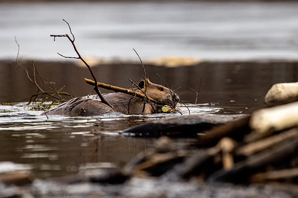
The beaver, the second-largest rodent in the world, is well-known for its wide, flat tail, used for slapping the surface of the water to warn other beavers of approaching danger. Trees provide a beaver’s favorite winter food — bark and leaves. In summer other vegetation, especially aquatic plants, make up their diet.
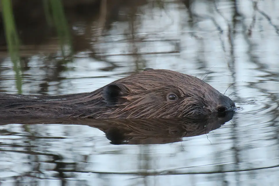
The American beaver can be found throughout North America, except for the most northern parts of Alaska. Like other beavers, its feet are webbed for better swimming. The ears and nose snap shut when the animal dives underwater, and the eyes have a third transparent eyelid that helps the beaver to see below the surface of the water. Its dense, yellowish-black, black, or reddish-brown fur retains body heat even in the coldest water. A secretive and nocturnal creature, it is awkward on land and thus vulnerable to predators.
Four to eight family members make up colonies and territories are marked with scent mounds —piles of mud that the beaver’s scent with glandular secretions. Beavers sometimes reside in a burrow at the water’s edge, but more often can be found setting up house in a dome-shaped lodge, built with branches and trees cut down with its large incisors.
Information utilized from http://animal.discovery.com/mammals/beaver/
The beaver, the second-largest rodent in the world, is well-known for its wide, flat tail, used for slapping the surface of the water to warn other beavers of approaching danger. Trees provide a beaver’s favorite winter food — bark and leaves. In summer other vegetation, especially aquatic plants, make up their diet.
The American beaver can be found throughout North America, except for the most northern parts of Alaska. Like other beavers, its feet are webbed for better swimming. The ears and nose snap shut when the animal dives underwater, and the eyes have a third transparent eyelid that helps the beaver to see below the surface of the water. Its dense, yellowish-black, black, or reddish-brown fur retains body heat even in the coldest water. A secretive and nocturnal creature, it is awkward on land and thus vulnerable to predators.
Four to eight family members make up colonies and territories are marked with scent mounds —piles of mud that the beaver’s scent with glandular secretions. Beavers sometimes reside in a burrow at the water’s edge, but more often can be found setting up house in a dome-shaped lodge, built with branches and trees cut down with its large incisors.