Brownfields Survey and Inventory

Inventory of Regulated Properties (IRP)

The Tribal Response Program has developed an Inventory of Regulated Properties (IRP) compiled into a geographically referenced data base that includes information useful to Environmental Professionals conducting “all appropriate inquiry into the previous ownership and uses of the property consistent with good comercial or customary practice” as defined at 42 U.S.C. §9601(35)
(B). The IRP has data with hundreds of properties with varying levels of detail including potential Leaking Underground Storage Tanks (LUST) and Brownfield sites.

During the field season of 2010 the Response Program conducted a detailed driving survey and distressed properties were visually identified, photographed, collected GPS coordinates. Where warranted, a limited title search was conducted in the appropriate county courthouse to determine the current property owners. This information was compiled into a Microsoft Excel database and merged with information from Tribal and EPA records. We are planning to enter property specific data into the University of Kansas Brownfield Inventory Tool, which will facilitate the compilation of property specific data into the ACRES database.

Properties on the inventory were then ranked on a scale from 1-5 to represent a semi-quantitative measurement of likely contamination: 5 is known contamination; 3 an active business that is commonly associated with contamination; and 1 representing properties with a low probability of contamination. The rankings of 2 and 4 allow for some subjective coloring of the property implying an intermediate status. If the property is vacant then it was added to our Brownfield Inventory for further evaluation.

Out of the hundreds of properties on the IRP, we identified 31 which appeared vacant, and titled this subset our Brownfields Inventory. The Response Program then ranked the Brownfield Inventory and selected 17 priority sites that we believed would benefit from having a Phase I ESA with a subset of these likely needing a Phase II ESAs. Parties interested in viewing the inventory are encouraged to contact the Response Program.

Blue North Mill Site

Former lumber mill located on the “Kamiah Bend” of the Clearwater River at Kamiah, Idaho (46.24168156095757, -116.02757343740886). Former lumber mill is located on 114 acres of riverfront property and is the site of a former winter village of the Nez Perce that hosted the Lewis & Clark expedition on their return east in 1806 as they waited for spring snowmelt to subside. The origin story for the Nez Perce Tribe centers on a basalt outcropping just upstream of the former mill site, indicative of the immediate area’s cultural significance to the Nez Perce Tribe. The site operated as a lumber mill from 1940 to 2016 under three operators; Potlach Corporation (1940-1980), Weyerhaeuser (1980-1995); Blue North Forest Products, LLC (2010-2016). The Tribe purchased the property from Idaho Forest Products, LLC in December 2018 who purchased the defunct mill from Blue North Forest Products and were in the process of salvaging mill equipment prior to sale to the Tribe. Recognized environmental concerns center around legacy contamination from decades of industrial-scale lumber milling; including boiler ash stockpiles, a 60-acre log yard, heavy equipment maintenance, fuel storage both above and below ground, transformer storage areas, and a sewage lagoon. Due to the age of the buildings on site, hazardous building materials including; asbestos, lead-based paint, mercury, and PCBs were enumerated and an abatement estimate generated by a Qualified Environmental Professional in August 2020. Currently, the site comprises of a 60-acre log yard with compacted and acidic soil, 17 remaining mill buildings, 4 building material debris piles, and 4 building foundations destroyed in a January 2018 fire during salvage operations across the 114-acre site. The site is also bisected by a defunct rail line, owned by Mike Williams, that once allowed transport of finished lumber down the Clearwater River towards coastal markets.

Fort Lapwai

The Fort Lapwai site is located in Lapwai, Idaho, approximately 0.5 miles south of City Hall in Lapwai, Idaho. The site consists of four buildings constructed by the Bureau of Indian Affairs (BIA), an open field formerly used as a parade ground for the U.S. military that occupied Lapwai, a baseball field, and a network of steam tunnels. present town of Orofino, Idaho. By the spring of 1861, thousands of prospectors descended across the Nez Perce Reservation. The prospectors set up mining camps, some of which rose to become boom towns, on Nez Perce land that had been set aside for a reservation as part of the Treaty of 1855. Unable to stem the tide of incoming miners, civilian authorities called on the military to establish a fort on the reservation to protect the Nez Perce. In 1862, the U.S. Army built Fort Lapwai, and negotiations began that would eventually lead to the Treaty of 1863.

The Treaty of 1863 shrank the size of the reservation established by the Treaty of 1855 by 90%, placing the newly discovered gold fields outside of the newly established reservation boundaries. Fort Lapwai ceased to function as a military fort in 1885. In 1886, portions of the fort were converted into the Fort Lapwai Indian Boarding School (a U.S. government-run school for Indians), which was eventually succeeded by the Fort Lapwai Sanitarium in 1910, both presumably housed in buildings original to Fort Lapwai. The bulk of the structures built in support of the fort were constructed between 1862 and 1884 and consisted of barracks for enlisted personnel, quarters for officers, stables, warehouses, offices, and corrals. Most of these buildings are no longer present at the site, and it is not known when they were removed from the site. However, the structure that served as the Fort Lapwai Indian Boarding School, and later the Fort Lapwai Sanitarium, is believed to have been present at the site until at least 1924.

Fort Lapwai Hazardous Building Materials Survey

Lapwai School Dist. Bus Barn

EXECITIVE SUMMARY

The Lapwai School District 341 Maintenance Shop/Bus Barn, located in Lapwai, Idaho, had 2 dry wells that were intermittently utilized by school district personnel to dispose of pesticide rinseates. Other potential sources of ground water contamination were identified during two EPA Underground Injection Control (UIC) inspections that was conducted September 9, 2002 and June 12, 2012. The Maintenance Forman thought the floor drains were connected to the municipal sewage treatment plant, but he was not able to provide documentation that this had occurred. It was recommended that these injection wells be further investigated and that the dry wells outside of the shop be permanently closed. The dry well’s are located less than 50 feet from municipal well BIA No. 1 and No. 2 that provides drinking water to the Lapwai Elementary School, Head Start Preschool, Nez Perce Tribal Offices, and Tribal homes totaling 300 hookups. Assessment work is on going.

SITE HISTORY

Tribal Unit 45 (TU-45)

EXECUTIVE SUMMARY:

Over a period of seven years the Nez Perce Tribe Tribal Response Program (TRP) investigated the 39-acre former sawmill site, Riverside/Richardson’s Sawmill (TU-45), located on the Nez Perce Reservation 1.5 miles east of Orofino, ID. The Tribe’s Economic Development Office was reluctant to redevelop the property due to uncertainties related to possible environmental contaminants. The TRP investigated eight possible contaminants, with a main focus on the identification of a clean source of drinking water unaffected by existing contaminants. Through a detailed soil sampling program and the drilling and sampling of 16 groundwater monitoring wells, the TRP has developed a comprehensive understanding of the distribution of contaminants on both the surface and subsurface and have documented the direction of groundwater flow across the site. Of the eight contaminants investigated, only perchlorate was found in levels exceeding the maximum contaminant level goals in groundwater as defined by the EPA. Two proposed drinking wells (MW-12 and MW-13) have been drilled on the north side of the property. They have been testing through pumping, sampling, and chemical analysis. Through interpretation of the hydrogeology at the site, the TRP believes these two wells are capable of providing clean drinking water to support site development. Creosote contamination was found in one half acre area on the southwest side of the property and scattered pentachlorophenol exceedances were found in soil, but not groundwater.

The water from the two proposed drinking water wells (MW-12 and MW-13) has been interpreted to come primarily from the riverbed of the adjacent Clearwater River. These wells are located upgradient on the aquifer and across the site from the likely source of the perchlorate contamination, which is carried by the groundwater flow paths to the northwest where it discharges into the Clearwater River. Long term pumping tests and sampling documented that these water wells produced clean water. Water level monitoring of the adjacent wells during the pumping tests documented that there was no measurable deflection of the water table, which indicates that the wells were unlikely to draw contamination towards the currently clean wells.

The TRP’s recommendations for Institutional Controls at the site were accepted by the Nez Perce Tribal Executive Committee. These three institutional controls were designed to manage environmental exposure to existing contamination and eventually eliminate ongoing and future contamination. With these institutional controls in place, this beautiful site is ready for redevelopment.

SITE HISTORY

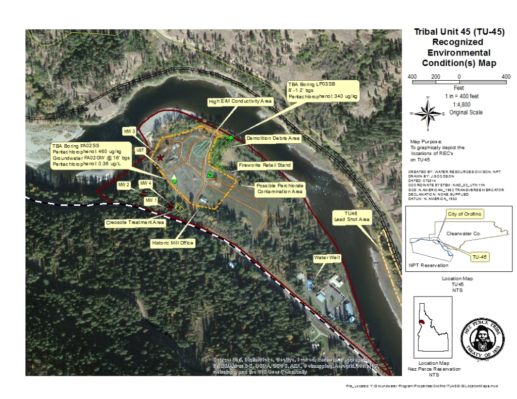
The Nez Perce Tribe (Tribe), Water Resources Division requested a property specific funding determination to continue with a Phase II Environmental Site Assessment on TU-45. Tentative redevelopment plans include a recreational venue, tourist facilities with a proposed boat ramp, tackle shop, and rental cabins. Tribal Unit (TU)-45 is a 38.9 acre property located 1.3 miles southeast of Orofino, Idaho, along the south bank of the Clearwater River. This property is managed in Trust by the Bureau of Indian Affairs (BIA) for the Nez Perce Tribe (Tribe). Current site activities include Teweepuu Community Center, Tribal Fisheries Office, and recreation focusing on fishing, swimming, walking, and seasonal fireworks detonation and sales. The significant historic uses of the site include the Richardson/Riverside Sawmill (1942-1980), Sverdsten Logging, sorting yard, (1983-1984), Seubert Excavators, asphalt batch plant, (1987-1991), WASCO, depositing demolition debris (1997), and various fireworks stands (1983-2014). A Phase I Environmental Site Assessment (ESA) was performed on TU-45 in conformance with the scope of work and ASTM Practice E 1527-05 in March 10, 2010. A Targeted Brownfield Assessment was funded and managed by EPA was completed in December 2011 and concluded that additional site characterization was needed. A Phase II ESA, managed and funded by Tribal Response Program (TRP), began in 2013 and includes trenching, soil sampling, geophysics, drilling of four monitor wells, and groundwater sampling. This revised Phase I ESA incorporates findings from the TBA, Phase II ESA findings to date, and presents the following professional opinions regarding recognized environmental conditions (RECs) at TU-45:

Tribal Unit 45 (TU45) Location and REC Map

Westgate / Kinzer Farm, Lapwai, ID

EXECUTIVE SUMMARY

SITE HISTORY

The Nez Perce Tribe (NPT), Water Resources Division requested to assess, sample, and clean up the 838.18 acre Westgate/Kinzer Farm (Westgate) property purchased by the Tribe on August 1, 1995 through public auction during foreclosure proceedings. The Westgate property is located on the Reservation approximately two miles from Lapwai, Idaho. The NPT has been unable to put the property into federal trust because of legacy oil contamination related to the operation of a farm machine shop prior to purchase by NPT, an open dump filling a portion of the North Fork Tom Beall Creek (and probable contamination of a domestic spring and groundwater from the dump), and soil contamination resulting from the vandalism of a barrel storage area by rifle and shotgun blasts, which resulted in an uncontrolled leakage onto the ground. Approximately 836 acres of Westgate is currently under cultivation with the principal crops being winter wheat, dry peas, and spring small grains. Approximately one to two acres are potentially contaminated. The NPT Land Service’s records from the date of eviction document a significant amount of oil staining around the farm machine shop. Westgate also includes several dilapidated out buildings and demolished home site. These environmental concerns have prevented the Bureau of Indian Affairs from accepting the property in trust.

From 1966 to 1995 the Westgate property had been leased to Marvin Kinzer, whose lease was canceled shortly after it was purchased by NPT. Mr. Kinzer subsequently vandalized the property. The NPT records report damages of $47,543, but the amount of insurance available was at the time of the claim was only $7,889. The farm house was subsequently demolished by the Tribe as it was believed to be beyond repair. The farmer currently leasing the land does not use the shop or abandoned buildings.

In November 2006, a barrel storage area located adjacent to the farm shop was vandalized by unknown person who shot 55 gallon barrels, 5 gallon buckets, and farm shop buildings with a rifle and shotgun. The barrels and buckets contained used oil, some solvents, grease, antifreeze, some pesticides, and water. Some of these drums were apparently left on site by Mr. Kinzer, while others were stored at the site by the NPT Wildlife Division, which inherited them from NPT Limestone Enterprises after the quarry was closed and Wildlife took over the quarry’s shop buildings. The NPT Wildlife Division later moved them from the old Limestone Enterprise office area to the Westgate Farm Shop area, which was believed to be a safe place to store them.

On February 1, 2007 the NPT Water Resources Division conducted sampling to characterize the remaining contents of the drums and buckets. The drums, buckets, and their contents were then removed by Chem Safe Environmental of Kittitas, Washington and transported for disposal under a hazardous waste manifest.

A farm-sized landfill is exposed in the headwaters of North Fork Tom Beall Creek approximately 50 to 100 feet from the farm shop. In the debris-filled stream channel, tires and empty pesticide barrels protrude from the soil. An abandoned concrete spring collection box is located within the creek channel at the toe of this landfill. A domestic water well is located approximately 200 feet downstream from the landfill, which is adjacent to the demolished farmhouse. An internal memo written by NPT Land Services Division to NPT Office of Legal Council described concerns over possible contamination of the water well.

 Characterization and cleanup of barrels and buckets at the site was done by NPT Hazardous Environmental Response Team (HERT) program members. There has been no regulatory action at this site. Cleanup of this property will allow the spring and associated wetland to be restored and the tribal land placed into federal trust. It would also allow for the repair and reuse of the shop building and other buildings on the property.

Kling & Peel, Ahsahka Idaho

 March 2003_ Abandoned UST(s) reported to Water Resource Division, Nez Perce Tribe

April 2003_ Field investigation by Water Resource Division confirmed past history of site as a small gas station that operated from 1920’s/30’s until late 1950’s. The site was reported to EPA, Seattle office.

August 2005_A site evaluation was conducted by Water Resource Division and a representative of Bristol Environmental and Engineering Services Corp.

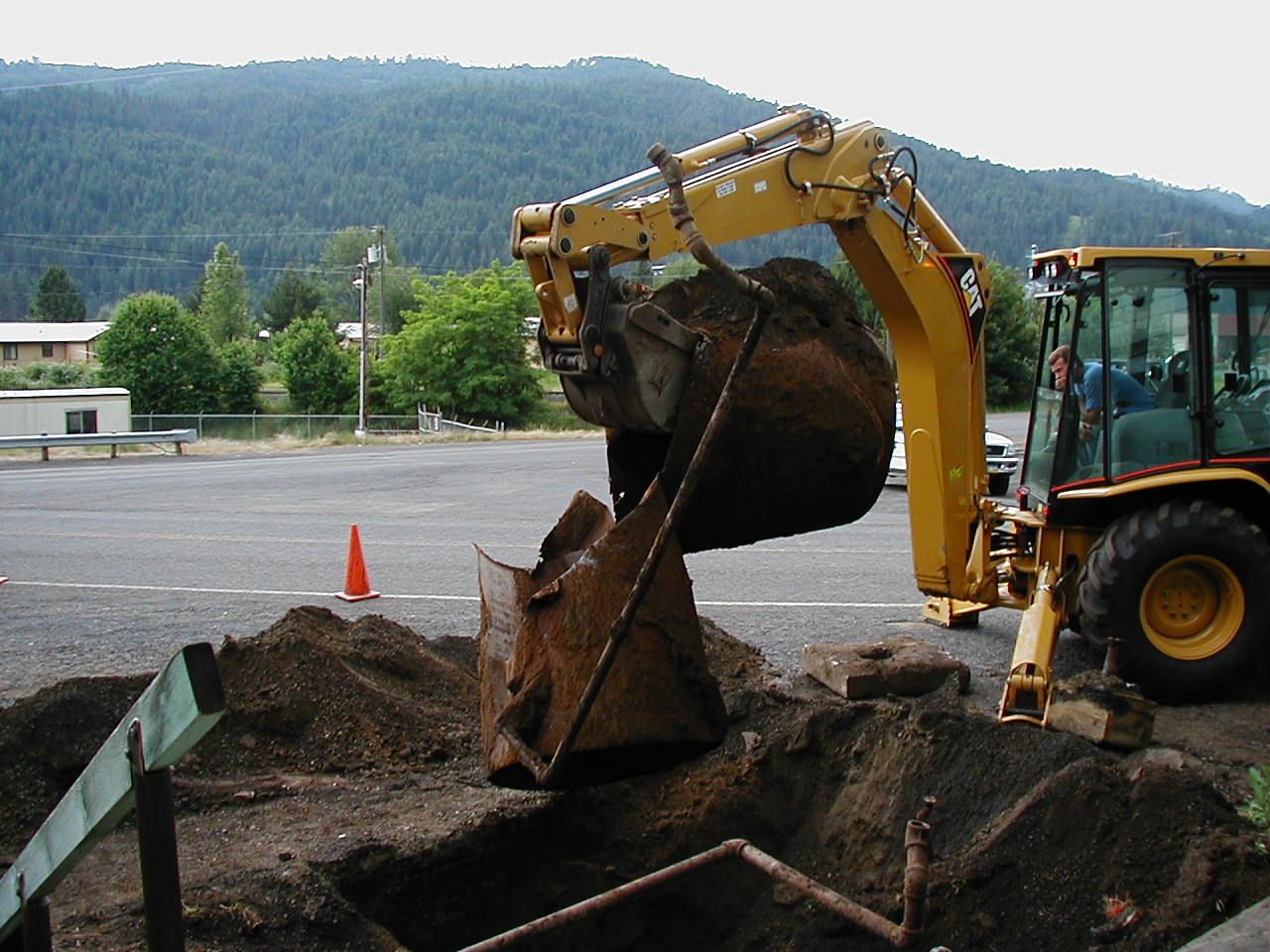
June 2006_Site Assessment activities included evaluation and removal of piping and two (2) 550 gal UST’s, that were cleaned, removed and scrapped for salvage. Results of soil samples taken for analysis were below Idaho Department of Environmental Quality, Initial Default Target Level.

December 2006_ No Further Action letter issued to property owner.

Rainbow Tavern, Ahsahka Idaho

Former gas station that operated from 1920’s or 30’s until late 1950’s with abandoned underground storage tank (UST).

March 2003-Abandoned USTs reported to Nez Perce Tribe

April 2003-Field investigation by Tribe confirmed site history and Tribe reported site to EPA.

August 2005-Tribe and a representative of Bristol Environmental and Engineering Services Corporations (Bristol) conducted a site evaluation.

June 2006-Tribe provided oversight for Bristol’s removal a 550 gallon UST, which was cleaned, removed, and scrapped for salvage. Results of soil samples taken for analysis were below Idaho Department of Environmental Quality’s Initial Default Target Levels.

December 2006-EPA issued No Further Action letter.

Work funded by EPA through LUST program. Site suitable for unrestricted use.

Tommy Samuel’s Garage, Ahsahka Idaho

 Former gas station that operated from 1920’s or 30’s until late 1950’s with abandoned underground storage tank (UST).

March 2003-Abandoned USTs reported to Nez Perce Tribe April 2003-Field investigation by Tribe confirmed site history and Tribe reported site to EPA.

August 2005-Tribe and a representative of Bristol Environmental and Engineering Services Corporations (Bristol) conducted a site evaluation.

June 2006-Tribe provided oversight for Bristol’s removal a 550 gallon UST, which was cleaned, removed, and scrapped for salvage. Results of soil samples taken for analysis were below Idaho Department of Environmental Quality’s Initial Default Target Levels.

December 2006-EPA issued No Further Action letter. Work funded by EPA through LUST program. Site suitable for unrestricted use.

Bovey Oil Company

EXECUTIVE SUMMARY

SITE HISTORY

Bovey Oil stored and dispensed petroleum fuels since at least the 1920’s. The facility closed for business in the late 1990’s as a retail service station/garage, and bulk fuel distribution operation. The most recent configuration consisted 10 USTs located in four basins, two pump islands, a fuel truck loading rack, and an office/station garage with a loading dock and a bulk containerized oil storage area.

Four 10,000 gallon (two diesel and two gasoline) USTs located on the south side of the station building provided fuel to the southwestern pump island while three 2,000 gallon (diesel/heating oil) USTs located on the east side of the station building provided fuel to the northeastern pump island. A 560 gallon kerosene UST was located on the southeast side of the station building near the fuel truck loading rack. Two 560 gallon USTs, one for waste oil and the other for heating oil to fuel the building’s furnace, were located on the west side of the property. The 10 UST systems (including tanks, associated piping and pump islands) were permanently closed by removal in July/August 2006. Also removed were 564 cubic yards of petroleum contaminated soil that were transported to another Bovey property near Winchester, ID, and placed in a 1-1.5 foot lift for landfarm treatment. During removal, the tanks were observed to be in good condition with no cracks or holes indicating that fuel releases likely resulted from overfills, improperly sealed pipe joints, and from connections at pump islands. The tank excavations were backfilled with clean, crushed rock.

Cottonwood Community Federal Credit Union

EXECITIVE SUMMARY

Cottonwood Community Federal Credit Union in Craigmont is a former a gas station known as Stop N’ Go and was in operation until the 1970’s. The property was also used as a smoke shop and pizza parlor. The Credit Union acquired the property and as part of the remodeling project had the 4 underground storage tanks (UST’s) decommisioned and removed in December of 2003 and a No Further Action letter was issued March 2004.

Craigmont Air Service

EXECUTIVE SUMMARY

Craigmont Air Service is a facility with legacy pesticide usage, extent of contamination in soil and groundwater are unknown. The City of Craigmont owns the 88.3 acres of mixed-use property that includes a paved lighted airstrip, adjoining crop land (currently leased), a commercial building leased to a private business, a summer fire crew quarters on a parcel leased by the Idaho Dept. of Lands, and the Craigmont Air Services operation (leased). The City has owned the property for over 80 years and has leased a portion of the site out as an agriculture aviation business for over 40 years. Craigmont Air Service has been the site of mixing and loading of pesticides for aerial applications. This site was also used for a small fixed-wing fire retardant base for the Idaho Department of Lands and the United States Forest Service.

Mr. Buck Erickson leased and operated an agriculture aviation business from the 1960s to 2001. The extent of Erickson’s use of the property has been difficult to determine due to his death in 2001. However, the Nez Perce Tribe and Region 10 EPA discovered now-banned pesticides remaining in the soil presumably used during his operation.

In 2001, Stan Bybee took over the lease and operated Craigmont Air Services, until 2005. Based on soil samples collected during an August 17, 2005, EPA RCRA inspection of Craigmont Air Services and a questionnaire filled out by Bybee, EPA concluded that Bybee was not responsible for the soil contamination because the pesticides were banned prior to his taking ownership of the business.

There were four UST’s on site; three of the UST’s with unknown capacity were removed in 1992 and one 12,000 gallon January 2010. A 500 – 1,000 gallon UST which was used for heating oil still remains. UST removal oversight, confirmation sampling and closure documentation were completed by the Nez Perce Tribe in coordination with IDEQ’s and EPA site assessment activities.

Prior to a new tenant purchasing the agriculture aviation business, the City of Craigmont plans to:

Site History:

Craigmont Shell

EXECITIVE SUMMARY

Craigmont Shell was built circa 1930 and operated until 1974. The current owner was told the tanks were removed prior to purchase. The antique dispensers were placed by the current owner.

Craigmont Trap Range

EXECUTIVE SUMMARY

SITE HISTORY

The American Legion and Craigmont Lions Club have an interest in redeveloping the Craigmont Trap Range site for a community baseball park. The baseball field will be placed in the northeast corner of the property within the hay field portion of the site. The American Legion and Craigmont Lions Club are proposing to develop an on-site lead-contaminated soil repository.


A Targeted Brownsfield Assessment occurred from November 1, 2009 to November 4, 2009 with Ecology & Environment, Inc. (E&E) as EPA contractors. In order to assess the possible presence of contamination within the property boundary, 165 soil samples were screened in the field for metals with an XRF instrument. In addition, 63 soil samples were submitted for fixed laboratory analysis (E&E 2010).

The Nez Perce Tribe (NPT) Water Resources Division has requested to assist in locating an alternative source of funds for construction, facilitating the lead repository permitting process, developing a stormwater pollution prevention plan, and verifying the cleanup process at the Craigmont Trap Range property located on the Reservation at Craigmont, Idaho.

The American Legion site is located in Craigmont, Lewis County, Idaho. The site has been used as a trap shooting range since it was purchased by the American Legion in 1936. The property is currently an undeveloped open grassy area that is bordered by A Street to the west, US-95 to the south, and East Lorahama Street to the north. East of the site is an agricultural field currently used for production of hay. No surface water features are located on-site (E&E 2010).

The shooting range fallout area extends into the adjacent hay field east of the range. Recently, the hay field was donated to the American Legion. The site is relatively flat and covered by grass. The areas of potential concern are the shot fallout range that extends out approximately 300 to 700 feet from the trap house in a horizontal plane with a 45 degree arc. Environmental concerns at the site are those common to small arms firing ranges and include potentially contaminated soil. Contaminants of concern include lead, arsenic, antimony, copper, tin, and various explosive residues (E&E 2010).

The X-ray fluorescence (XRF) screening and fixed laboratory sample results revealed that the majority of the exceedances encountered on site are located in the southeastern portion of the site beginning approximately 300 feet south east of the trap house. This information is in agreement with the technical/regulatory guidelines put forth by the Interstate Technology and Regulatory Council Small Arms Firing Team within the Characterization and Remediation of Soils at Closed Small Arms Firing Ranges guidance (ITRC 2003). This guidance states that most shot fall lands approximately 375 to 770 feet downrange of the trap house, with a 45 degree arc (E&E 2010).

Fixed laboratory sample results indicate the presence of lead in surface and subsurface soil samples above criteria values at 15 locations. XRF and fixed laboratory TAL metals results showed an acceptable correlation during the linear regression analysis. Therefore, XRF field screening achieved the objective of identifying areas of contamination and of determining the extent of contamination (E&E 2010).

Thomason Chemical Co., Inc., Craigmont ID

EXECITIVE SUMMARY

Thomason Chemical is located at the corner of Front Ave. and Third St. Craigmont, ID. The property was acquired in 1968 and additions were made to the building in 1974 and during the 1980’s. The site consists of one main building with additions and a smaller shed directly adjacent to the main building. The main building was previously used for commercial use in manufacturing metal products. Currently the building is filled with tools and materials used in the prior business and the smaller shed is empty. The shop was closed in 1990 and building abandoned in 2008. Mr. L. Thomason met with Environmental Restoration and Waste Management (ERWM) and Water Resources, Nez Perce Tribe April 2013 to discuss how the property evolved and the industrial applications. Mr. Thomason’s concerns involving chemical and hydrocarbon contamination and unidentifiable surplus from the Hanford Nuclear site.

Water Resources conducted a site visit and identified areas of concern. A report was generated and forwarded to Mr. Lincoln suggesting a Phase II Environmental Site Assessment (ESA) was needed to address areas of environmental concerns. Keltic Engineering was retained by the site owner and performed the Phase II ESA and environmental sampling in June 2013. Keltic Engineering recommendations in their report dated July 2013 that base upon lab results there are no significant environmental impacts at this site.

SITE HISTORY

April 12, 2013 ERWM was contacted by Mr. L. Thomason and made aware of a potential radioactive object land he is a representative for at 3rd and Front in Craigmont.

April 15, 2013 ERWM and Water Resource meeting with Mr. L. Thomason regarding unidentifiable surplus from the Hanford Nuclear site as possible nuclear material

April 15, 2013 ERWM requested assistance for the Dept. of Energy for assistance with classification of object.

April 19, 2013 Region Response Team 2 and Department of Energy, Region VIII response teams were contacted for an immediate response.

April 22, 2013 Officials with the Idaho Bureau of Homeland Security said a regional response team deemed the level of radioactivity very low, and the material didn’t pose any immediate threat to life or safety. The material was removed and returned to Hanford. No background radiation was detected at the site and the response action was ended.

May 1, 2013 Water Resources conducted a site inspection and 6 site concerns were listed.

June 20, 2013 Keltic Engineering was retained by the site owner and performed the Phase II ESA and environmental sampling. And base upon lab results there are no significant environmental impacts at this site.

US Timber, Craigmont ID

Site where Two 10,000 gal USTs were apparently decommissioned in the 1980’s, but no records were kept at the time.

1997-Wyatt Engineering conducted an Environmental Site Assessment.

October 2005-USKH Inc conducted a Phase 1 Environmental Site Assessment.

November 2005-A 10,000 gal diesel UST was decommissioned and removed by Roach Construction. Soil samples were collected and delivered to Anatek Labs. The results of the lab tests show all concentrations were below the Idaho Initial Default Target Levels.

January 2006-Tribe provided oversight while USKH, Inc. completed their Environmental Site Assessment. USKA reported with the following concerns:

February 2006-Owner requested EPA grant permanent closure.

March 2006-EPA issued a No Further Action letter.

July 2010-Clearwa

A Phase I Environmental Site Assessment (ESA) was conducted to document the condition of the site, check the AST area for signs of leakage, or suspected locations of remaining UST’s. The tanks were removed while Channel Lumber Company owned the property and before the site was sold to U.S. Timber Company, but no documentation was collected at that time, and none is available now. US Timber ceased operations in 1998. Currently the site is home to Ende Machine and Foundary

1980 Two 10,000 gal USTs were apparently decommissioned but no records were kept at the time.

1997-Wyatt Engineering conducted an Environmental Site Assessment.

October 2005-USKH Inc conducted a Phase 1 Environmental Site Assessment.

November 2005-A 10,000 gal diesel UST was decommissioned and removed by Roach Construction. Soil samples were collected and delivered to Anatek Labs. The results of the lab tests show all concentrations were below the Idaho Initial Default Target Levels.

January 2006-Tribe provided oversight while USKH, Inc. completed their Environmental Site Assessment. USKA reported with the following concerns:

Used oil stored on site needs to be properly disposed.

If buildings are to be removed, asbestos testing should be conducted; i.e. tile, linoleum and roofing materials.

February 2006-Owner requested EPA grant permanent closure.

March 2006-EPA issued a No Further Action letter.

July 2010-Clearwater Economic Development Association finalized purchase of 20 acre site.

June 2011-Ende Machine Foundry, a precision cast lost foam foundry, opens.

Work funded by US Timber.

Site suitable for unrestricted use.

Leo Hasenoehrl, Culdesac ID

Private property owner with an underground storage tank for agricultural equipment fueling

May 2008-UST field notice of non-compliance was issued under 40 CFR 280.70 for failure to permanently close or upgrade a temporarily out-of-use UST system. The corrective action required the 5,000 gallon UST to be removed by July 14, 2008

June 2008-Leo Hasenoehrl removed the tank himself with oversight by the Nez Perce Tribe. A site assessment was not required because of the infrequent use of UST and no contamination was found during the removal process.

June 2008-Tribe issued a No Further Action letter.

Work was funded by Leo Hasenoehrl

Suitable for unrestricted use

Ferdinand Service Station (Phillips 66), Ferdinand, ID

EXECUTIVE SUMMARY

Former gas station where one underground storage tank (UST) was removed and one UST cleaned out and left in place

SITE HISTORY

In 1951 two USTs with a 550 gallon capacity were installed at the Ferdinand Gas Station. One was located underground inside the gas stations exterior walls. In 1997 the USTs were pumped out and locked when the gas station closed. In 2008 the UST and product lines underneath the building could not be removed because they were located under the hydraulic lift in the shop building. A hole was cut in the top of the UST and the tank was cleaned out. A hole was cut through the bottom of the tank to sample the soil beneath, but groundwater entered the hole and the sample could not be collected. A second hole was cut through the side of the tank and a soil sample collected. The sample exceeded the Idaho Department of Environmental Quality’s (IDEQ) Initial Default Target Levels (IDTLs). The tank and product lines were filled with concrete grout (Bristol 2009).

The outside UST was located 13 feet below ground surface (bgs). The UST was inerted, cleaned, and removed. Fuel odor was apparent in the soil. The UST was in poor condition, rusted, and with obvious holes on one end. After removal of the UST, the excavation was dug to a depth of 15 feet bgs to remove the contaminated soil. Approximately 24 cubic yards of petroleum contaminated soil (PCS) was removed and stockpiled. The stockpile was covered with visqueen until it was loaded and transported to a disposal facility. The soil sample results from the outside UST indicated that two samples exceeded IDEQ’s IDTLs (Bristol 2009).

In 2009 Bristol removed an additional 190 cubic yards of PCS and disposed of it at Jackson’s Dirt Farm, collected soil samples; and installed, developed, and sampled three groundwater monitoring wells to assess the groundwater conditions beneath the site (Bristol 2010).

Based on the 2009 groundwater analytical results, groundwater beneath the site was impacted with benzene, ethylbenzene, and naphthalene. The well located near the residence was the most contaminated, it contained benzene, ethylbenzene, and naphthalene above the IDEQ IDTLs. The well located at the northwest corner of the shop had elevated benzene in the groundwater (Bristol 2010). In 2009, thru 2013 groundwater sampling continued.

In 2010 a vapor intrusion investigation was conducted by the Nez Perce Tribe Water Resources Division to determine if soil vapors pose a health risk to residents at the site. The air sampling results were inconclusive and a second vapor intrusion investigation is not warranted.

Flying B Ranch, Kamiah ID

2009 – A 1000 gallon UST used for unleaded gasoline and a 500 gallon UST used for off-road diesel were removed, tanks were found to be in good condition, soil contamination came from delivery or spillage while fueling vehicles, 9.5 cubic yards of soil was removed and landfarmed on site, EPA issued a Permanent Closure letter

Work funded by Flying B Ranch

Site suitable for unrestricted use

Lapwai School Dist. Bus Barn

EXECITIVE SUMMARY

The Lapwai School District 341 Maintenance Shop/Bus Barn, located in Lapwai, Idaho, had 2 dry wells that were intermittently utilized by school district personnel to dispose of pesticide rinseates. Other potential sources of ground water contamination were identified during two EPA Underground Injection Control (UIC) inspections that was conducted September 9, 2002 and June 12, 2012. The Maintenance Forman thought the floor drains were connected to the municipal sewage treatment plant, but he was not able to provide documentation that this had occurred. It was recommended that these injection wells be further investigated and that the dry wells outside of the shop be permanently closed. The dry well’s are located less than 50 feet from municipal well BIA No. 1 and No. 2 that provides drinking water to the Lapwai Elementary School, Head Start Preschool, Nez Perce Tribal Offices, and Tribal homes totaling 300 hookups. Assessment work is on going.

SITE HISTORY

Winchester Hotel, Winchester ID

Executive Summary:

The Winchester Hotel located at 605 Nez Perce Ave, Winchester ID, was demolished by the site owner January 2012. Local residents collected much of the old timber and beams. A complaint was lodged with EPA of the possibility of asbestos in the debris August 2012. The owner had an AHERA certified building inspector complete an asbestos survey July 2013 as required by EPA. Laboratory analysis documented that the site is free of asbestos.

Site History:

Site is ready for redevelopment